This Sensor Assurance Framework (SAF) project aims to create a reliable and usable framework for understanding how well AV perception sensors (the eyes and ears of the vehicle) perform in different weather-related conditions. When fully developed, this framework will support validation, safety assurance and simulation testing of AVs across the UK.
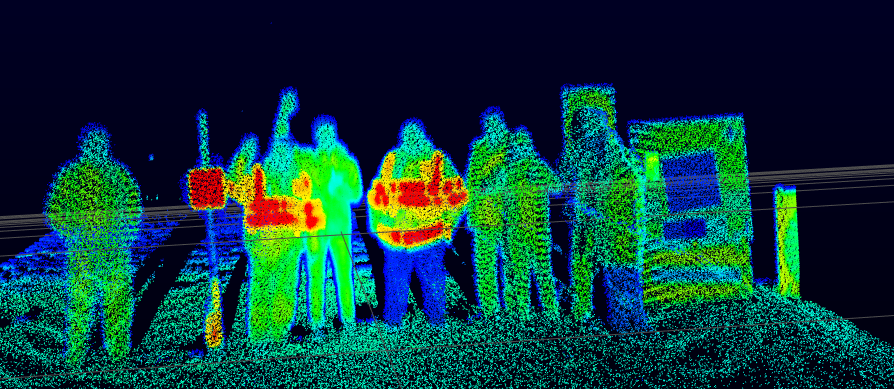
Central to SAF project has been the Cardington weather-sensor testbed, which has accumulated over two years of detailed weather measurements and corresponding AV sensor measurements as they observe targets set up at varied distances in a wide range of weather conditions including fog, intense rainfall, clear and cloudy skies and direct sunlight.
Weather observations are made at the Cardington test site to compare with sensor performance
Met Office Observations Principal Consultant Dave Jones, who is part of the team leading the weather measurement side of the Cardington testing, said: “The effect of weather on sensor performance is very complex and it is challenging to reflect this when trying to capture the weather envelope for the AV as simply as possible.
“This discussion paper gives examples of how this complexity reveals itself on our testbed and how we might begin to handle this by careful consideration of uncertainty. We are very interested in hearing views from everyone in the wider AV community involved in safety assurance.”
National Physical Laboratory’s Andre Burgess, who looks after strategic partnerships, said: “As well as the scientific and technical aspects of our joint SAF project, we are placing a huge emphasis on engagement with regulators, industry, standards bodies and academia to ensure that these testbed results make a positive difference to the AV industry and public safety.”
The Met Office and NPL’s Sensor Assurance Framework research at Cardington has been undertaken for around two years, with the aim to test sensor performance against as many different weather types as possible, including rain, hail, sunshine and fog.
The research so far demonstrates an observable relationship between weather conditions and sensor performance, though further study is needed to fully understand this area, including the impact of different locations, road surfaces, vehicle movements and a broader range of weather types. It’s hoped this research will help the autonomous vehicle industry to develop further in the coming years.
The Met Office and NPL will continue collecting weather data and assessing sensor performance in the coming months, with a new testbed at NPL’s headquarters in Teddington and plans to develop a relocatable testbed which can be deployed in a wider range of weather conditions.
The SAF principles also extend to marine autonomous vehicles. Plans are already well underway to build a demonstration testbed around Plymouth Sound UK, as part of the Maritime Autonomy Assurance Testbed (MAAT) project, which is lead by NPL and Lloyds Register with partners including the Met Office, Plymouth Marine Lab (PML), University of Plymouth, and Warwick Manufacturing Group (WMG).
Warmer weather, flooding, and droughts are already affecting rugby, but how will the increasing effects of climate change impact rugby in the future?
A new report by World Rugby (the rugby union governing body), has identified six major climate risks which could impact the sport, either directly or indirectly, in the future if action is not taken to increase the sport’s resilience against the risks of climate change.
The Climate Change and Rugby report investigated climate hazards across ten countries (Argentina, Australia, England, Fiji, France, India, Japan, New Zealand, South Africa, and the USA), and found there would be significant impacts for each region if global average temperature were to reach levels of +2°C above a pre-industrial level.
The IPCC Sixth Assessment Report (AR6) states that since the Industrial Revolution, the average temperature of the planet has risen by around 1.1°C.
Using a methodology which includes projections alongside observations, research by the Met Office indicates the current global warming level could be as high as 1.25°C. This is a rapid change in terms of our global climate system and is already leading to changes in the extreme weather we experience on the Earth’s surface.
Extreme heat days
As global temperatures rise, so do the instances of extreme heat days (days in which the temperature exceeds 35°C). This not only puts rugby players at risk, but fans of the sport too. This has been seen in other sports in the past where matches have needed to be called off because of scorching temperatures. For example, in 2014, play had to be suspended on all uncovered courts for more than 4 hours at the Australian open due to temperatures rising to over 40°C, causing a risk of heat exhaustion or heatstroke for the athletes.
World Rugby’s report found that six out of the ten countries they investigated would face ten or more additional days each year where playing rugby would be ill advised or even impossible due to climbing temperatures.
Increased frequency and intensity of droughts
Droughts affect the availability of water, and reduced access to this resource could result in drier, harder and less grassy pitches. The report indicates that dry conditions will reduce the quality of playing surfaces, affecting ball bounce and player movement. This could also increase the risk of players getting injured when athletes tumble onto hard ground. Half of all countries in the study would likely see an increase in the frequency and intensity of droughts, leading to less days where pitches are suitable for use.
Marine submersion and flooding risks
The report shows that rising sea levels pose a threat to stadiums near the coast, while flash floods caused by the increased frequency and intensity of rain pose a threat to both coastal pitches and those further inland. Floods could make stadiums inaccessible for extended periods of time, as even after the water subsides, turf and building structures can be left with substantial damage. Repairing stadiums after flooding can be costly and take a long time. World Rugby says that 11% of the 111 stadiums in the report can expect to see an increased annual submersion risk, while eight out of ten countries studied will face an increase in the frequency and intensity of heavy precipitation and flash floods.
Increased humidity
Increased humidity can cause additional heat-related suffering for athletes, officials, and spectators. Higher levels of humidity can make heat feel more intense and reduce the body’s ability to perform certain functions, such as sweating. Additionally, high levels of humidity can cause issues with the health and growth of certain grass varieties that may be used on pitches. The report found that most climate regions will experience periods of higher humidity, impacting the ability to play rugby.
Adaptation
To reduce the impacts of climate change on rugby, some adaptations will need to be made in the future. World Rugby has suggested in their report the development and implementation of individual sustainability plans, to help reduce rugby’s environmental impact. As well as this, climate projections will need to be considered when implementing new policies to prepare the game for a changing climate.
In a recent blog, we shared details of a piece of work by the Met Office which explores expected future climatic conditions for a range of range of cultural, sporting and social events across the UK. The study compares observations and climate projections for temperature and rainfall may change in the future for the start of the Six Nations (February) at the Twickenham (London), Murrayfield (Edinburgh) and Principality (Cardiff) stadiums.
Climate change already has, and will likely continue to affect rugby, but with research and the implementation of new strategies and adaptation, risks can be minimised to allow fans and athletes to continue to enjoy the sport.
The Met Office has just published its latest briefing on Arctic and Antarctic sea ice.
The update doesn’t reveal any record-breaking figures, but it does reveal that sea ice loss remains a serious issue.
Alex West who co-ordinates the sea ice briefings said: “After last year’s record-breaking minimum extent of sea ice in the Antarctic, the latest update shows greater sea ice extent than last year, but it is still the second lowest on record for the time of year.
Following a warm June, Arctic sea ice extent is below average for the time of year but some way above record low levels, with conditions fairly typical of recent years.
“Extent is particularly low in the Laptev Sea and in the Atlantic sector, but nearer average in other parts of the Arctic.
“This year’s September Arctic sea ice extent is likely to be well below average, but there are not yet heightened indications of a new record low.”
The Advancing Arctic Capabilities programme – a new project led by the Met Office -brings international partners to develop an improved understanding of what is happening to the region’s ice, ocean and atmosphere to support global climate resilience.
The project will deliver cutting-edge insights into Arctic weather patterns and ocean currents.
Hurricane Beryl, which has been tearing through the Caribbean, has been hitting the headlines for several reasons.
Firstly, there is the undeniable fact that during her existence as a Category 4 and 5 hurricane Beryl caused much damage and loss of life across several nations and territories, including Grenada, St Vincent and the Grenadines, Jamaica and the British Overseas Territory of the Cayman Islands.
Satellite image of Hurricane Beryl crossing Jamaica in early July 2024
Secondly, Beryl has become infamous for being the earliest Category 5 hurricane in the historical record in the Atlantic Basin. Category 5 is the highest ranking for hurricanes requiring sustained wind speeds of at least 157 mph. Hurricane Beryl’s wind actually peaked at 165 mph on 2 July. The earliest date in the year any previous Atlantic hurricane had achieved winds of this strength was a full month later on 5 August.
Active hurricane season
Julian Heming is a Met Office tropical cyclone expert who has been studying these systems for many years. He said: “In the second half of May several prediction centres, including the Met Office, forecast an active Atlantic hurricane season with between 150% and 200% of usual activity.
“These Atlantic seasonal forecasts have been influenced by the development of cooler waters in the equatorial eastern Pacific in recent months – in line with the anticipated La Niña or cooler phase of the naturally-variable El Niño Southern Oscillation (ENSO) cycle.
“Developing La Niña conditions have a known association with a more active Atlantic hurricane season. So, we know that natural variation in the climate system has a huge observable effect on hurricane activity.
“But this trend towards La Niña favouring hurricane development would not solely explain Hurricane Beryl and the prediction of an active hurricane season.
“Sea temperatures across the tropical Atlantic and Caribbean Sea have been well above average since the Spring of 2023 which provides fuel for intense hurricanes like Beryl. There is much meteorologists do not yet understand about how these high sea-surface temperatures have developed and why they have persisted for so long. This is an active area of research.”
“Furthermore, higher sea-surface temperatures in line with a warming climate are expected to favour the development of a greater proportion of intense tropical cyclones in the long term.”
International effort
Will Lang is the Met Office’s head of Situational Awareness. He said: “Met Office forecasts are a crucial part of the international effort to predict Atlantic hurricanes, and our experts work at the heart of UK Government’s international response to damaging hurricanes such as Beryl.”
You can watch an interview about Hurricane Beryl here.