Weather
One in 250-year event underway high in the atmosphere.

For the first time since records began in the mid 20th century , this extended winter period (November to March) is the first in our observational records to see three Sudden Stratospheric Warming (SSW) events. Met Office research suggests the likelihood of having three SSW events in one winter period is just a one in 250-year chance, although it is more likely to happen during an El Niño winter, such as this winter.
The record of SSW events goes back to the 1950s with the introduction of radiosonde balloons which are used to take observations high in the stratosphere on a routine basis. Since then, there has been typically one SSW every two extended winters. However, there are occasional runs of years with no warming events at all e.g. in the 1990s. There are also winters with two warmings such as the winter of 2009/10.
Professor Adam Scaife, Head of Long-Range Forecasting at the Met Office, said: “Although we have not seen it before, we recently documented the chances of an unprecedented three SSW events happening in one winter. Our research work, using multiple computer simulations, showed that this could occur about once in every 250 winters.”
Professor Scaife added, “Although this is very rare, we also found that the chance of multiple SSW events is increased during El Niño and so the chance of multiple events this winter is raised.”
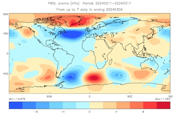

Forecast pressure for mid-March showing relatively high pressure over Iceland and low pressure over mid latitudes (Units: hPa).
A SSW is a disruption of the normal westerly air flow 10 to 50 km above the earth. This often makes the jet stream meander more, which can lead to the development of a large area of high pressure over northern Europe at the Earth’s surface. This can ‘block’ the Atlantic low-pressure systems which are responsible for the relatively mild, wet and windy weather that often occurs in UK winters. This blocking pattern increases the chance of cold, dry weather in the UK and mild, wet and windy conditions for southern Europe. However, the impacts of an SSW do not always equate to cold weather, for example, we have only seen intermittent drops in temperature around the two SSW events early this winter and typically around 70% of events are associated with a cold snap.
SSW is just one of a number of global drivers that can affect weather in the UK, the current SSW is consistent with the latest long-range outlook for March which suggests a continued increased chance of blocked, high-pressure conditions to the north of the UK and a southward shift in the Atlantic jet stream.